1/6
OpenTrail screenshot 0
OpenTrail screenshot 1
OpenTrail screenshot 2
OpenTrail screenshot 3
OpenTrail screenshot 4
OpenTrail screenshot 5
OpenTrail Icon

OpenTrail

Nick Whitelegg
Trustable Ranking Icon
1K+ダウンロード
14MBサイズ
Android Version Icon4.4 - 4.4.4+
Androidバージョン
0.6.0(21-07-2021)
-
(0 レビュー)
Age ratingPEGI-3
ダウンロード
詳細レビュー情報
1/6

OpenTrailの説明

** PLEASE NOTE that footpaths are only available in those areas in which they have been mapped in OpenStreetMap. Apologies for not making this clear originally. **

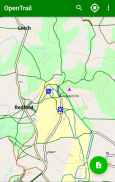
OpenTrail is an OpenStreetMap-based walking app for England and Wales, highlighting public rights of way and other paths which have public access and including contours from Ordnance Survey OpenData.

You can also search for nearby points of interest.

There are occasional, non-serious rendering artefacts - for example some lakes do not show up properly due to database issues (rather than the app itself); some aspects of the OpenStreetMap data model are not currently supported by the app.

OpenTrail is an open source application licensed under the GPL. See https://github.com/nickw1/opentrail.

OpenTrail - バージョン 0.6.0

(21-07-2021)
新機能はNow using Tangram for map rendering, to give a consistent style with Freemap.Users can annotate map with notes.

まだ、レビューや評価はありません。 して最初のレビューワーになってください。

-
0 Reviews
5
4
3
2
1

OpenTrail- APK情報

APKバージョン: 0.6.0パッケージ: freemap.opentrail
Androidでの対応: 4.4 - 4.4.4+ (KitKat)
開発者:Nick Whiteleggプライバシーポリシー:https://hikar.org/#privacy許可:3
名前: OpenTrailサイズ: 14 MBダウンロード: 0バージョン : 0.6.0リリース日: 2021-07-21 16:13:58最小スクリーン: SMALLサポートされたCPU: x86, x86-64, armeabi-v7a, arm64-v8a
パッケージ ID: freemap.opentrailSHA1署名: 9F:68:10:5C:F3:0F:06:E7:6A:0C:D3:2C:8C:71:10:37:8E:53:4C:A9開発者 (CN): Nick Whitelegg組織 (O): Freemap地域 (L): Southampton国 (C): 都道府県/州/市 (ST): UKパッケージ ID: freemap.opentrailSHA1署名: 9F:68:10:5C:F3:0F:06:E7:6A:0C:D3:2C:8C:71:10:37:8E:53:4C:A9開発者 (CN): Nick Whitelegg組織 (O): Freemap地域 (L): Southampton国 (C): 都道府県/州/市 (ST): UK
appcoins-gift
ボーナスゲームさらに多くの報酬を獲得!
さらに